
10.1 Polar Coordinates
The Cartesian coordinate system is also called the rectangular coordinate system, because it describes a location in the plane as the vertex of a rectangle. To construct a rectangular coordinate system, we begin with two perpendicular axes that intersect at the origin. The - and -coordinates of a point indicate the length and width of a rectangle with one vertex at the origin. The point sits at the opposite vertex of the rectangle, as shown in the figure below.
In Chapter 9 we used vectors to specify a location by giving a distance and a direction. For example, we might say that the airport is located 5 miles southwest of the city center. This method of designating locations is so useful that we will construct a new coordinate system using the same tools: distance and direction.


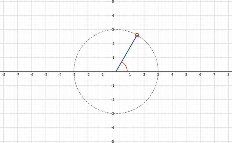
In the polar coordinate system we start with the origin or pole, and a single ray from the pole, called the polar axis. We describe the location of a point in the plane by measuring the distance, , from to the pole, and the angle, , that makes with the polar axis (measured counterclockwise). The components of the ordered pair are called the polar coordinates of the point .
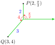
In our work with polar coordinates, we will always use radians for the angle . For example, the point is located 2 units from the pole at an angle of radians, and is located 3 units from the pole at an angle of 4 radians. The graphs of and are shown at right.
A piece of graph paper in rectangular coordinates consists of a grid of horizontal and vertical lines. These are the lines and , for evenly spaced values of . Each vertical grid line consists of points that have the same -coordinate, and each horizontal grid line is made up of points that have the same -coordinate. The grid lines are bench marks to help us locate points with specific rectangular coordinates.
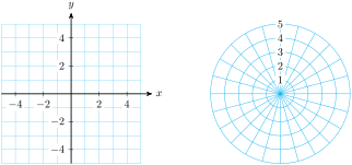
A piece of graph paper in polar coordinates consists of a grid of concentric circles and radial lines, as shown below. Each circle consists of points with the same -coordinate; they are all the same distance from the pole. All points with the same -coordinate lie on one of the radial lines. This grid helps us locate points with specific polar coordinates.
Plotting Points
You are used to thinking in rectangular coordinates: to locate a point, we move so many units left or right, and so many units up or down. When working in polar coordinates, we want to "think radially:" how far to move from the pole, and in which direction.
Give the polar coordinates of the points and shown at right, with .

,
Each point has infinitely many polar coordinates, because we can add multiples of to the value of . For example, the point with polar coordinates also has polar coordinates and .
If we allow negative values of , there are even more ways to write the coordinates of a point. Each angle designates a line through the pole, and each line has both a postive and a negative direction.
On the line at , for instance, the positive direction lies in the first quadrant, so that the point is designated by in the figure at right. To plot the point , we move in the opposite direction from the pole, arriving at point . Note that the point can also be designated by the coordinates .

Give polar coordinates with positive -values and for each point given in polar coordinates.
Regions in the Plane
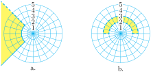
In Cartesian coordinates, we use equations and inequalities to describe regions in the plane. For example, the shaded region in figure (a) is the graph of . The pair of inequalities describes the region in figure (b). This region is particularly simple, in that its boundaries are portions of the coordinate grid lines and , where is a constant.
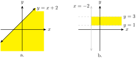
In the polar plane, the coordinate grid lines are circles centered at the pole, with equations , and lines through the pole, with equations .
Write inequalities to describe each region shown below.
- ,
Converting Between Polar and Cartesian Coordinates
Using trigonometry, it is easy to convert from polar coordinates to Cartesian, or vice versa. The figure below shows how the two sets of coordinates are related.
If we know the polar coordinates , we can compute the Cartesian coordinates as the legs of a right triangle.

Find the Cartesian coordinates of the point with polar coordinates .
If we know the Cartesian coordinates of a point, we can compute the polar coordinates as follows.
To find the angle , it is not enough to compute ; we must choose the angle in the same quadrant as the given point.
Find polar coordinates for the points with Cartesian coordinates . Give decimal approximations rounded to hundredths.
Equations in Polar Coordinates
Polar coordinates are useful for studying objects or phenomena that have radial symmetry, such as circles, spheres, and cylinders, or the central forces (those that act equally in all directions), such as gravity and electric charge. The equations describing these objects are often simpler in polar coordinates than they are in Cartesian coordinates.
It is not hard to convert an equation from Cartesian to polar coordinates: we replace each with and each with .
Convert the equation to polar coordinates.
Note that
so we have , or , a circle of raidus 2.
Perhaps you recognize the equation in the previous exercise as a circle. Note also that its polar equation has a simpler form than the familiar Cartesian version.
Converting equations from polar to Cartesian form is not as straightforward as the other direction (and is sometimes impossible). Here are some strategies to try:
- Expressions of the form or can be replaced by and , respectively.
- can be replaced by .
- can be replaced by .
Convert the equation to Cartesian coordinates.
Start by squaring both sides and then replace each side by its Cartesian form. Then solve for to get
Review the following skills you will need for this section.
Section 10.1 Summary
Vocabulary
- Pole
- Polar axis
- Polar coordinates
Concepts
- In the polar plane, the coordinate grid lines are circles centered at the pole, with equations , and lines through the pole, with equations .
- To convert an equation from Cartesian to polar coordinates, we replace each with and each with with . To convert an equation from polar to Cartesian coordinates, look for expressions of the form , or .
Study Questions
- Why is the Cartesian coordinate system sometimes called the rectangular system?
- What do the graphs of the polar equations and , where is a constant, look like?
- Fill in the blank: the point with polar coordinates also has coordinates .
- What does the region described by look like? What does the region described by look like?
- Sketch a figure that explains how to convert between polar and Cartesian coordinates.
Skills
- Plot points in polar coordinates #1–8
- Write polar coordinates for points #9–16
- Convert Cartesian coordinates to polar #17–24
- Convert Polar coordinates to Cartesian #25–32
- Write alternate versions of polar coordinates #33–38
- Sketch a region described by polar inequalities #39–44
- Write polar inequalities to describe a region #45–50
- Convert an equation to Cartesian coordinates #51–64
- Convert an equation to polar coordinates #65–72
Homework 10-1
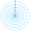
For Problems 1–8, use the grid below to plot the points whose polar coordinates are given.


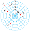
For Problems 9–16, give polar coordinates for each point shown below, with and .
For Problems 17–24, convert the polar coordinates to Cartesian coordinates.
For Problems 25–32, convert the Cartesian coordinates to polar coordinates with and . Give exact values for and .
In Problems 33–38, polar coordinates are given.
- Convert to polar coordinates with .
- Convert to polar coordinates with .
For Problems 39–44, sketch the region described by the inequalities.
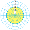

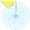
For Problems 45–50, write inequalities to describe the region.


For Problems 51–64, convert the equation into Cartesian coordinates.
For Problems 65–72, convert the equation into polar coordinates.
Use the Law of Cosines to prove the distance formula in polar coordinates:
Show that the graph of is a circle. Find its center and radius.
Trigonometry by Katherine Yoshiwara (yoshiwarabooks.org), GNU Free Documentation License 1.2 or later. Adapted for the XYZ HTML edition with the authors' permission (recorded 2026-07-04). License: GFDL-1.2-or-later.